My brother and I took a little cultural/genealogical excursion this past weekend. As usual, we talked history, politics, and books; ate good food; visited some interesting places; and had a couple of frustrating experiences that we turned into a really good story. So here's the story.
My brother wanted to check out the Crystal Bridges Museum of Art in Bentonville, Arkansas, thinking it would be a fun destination for his wife and him when they become empty-nesters next month. We both love long drives and small towns, and we planned to visit the museum and maybe walk around the historic parts of Bentonville and Fayetteville. From our hotel between Springdale and Fayetteville, we planned to venture out on the second day to find the grave of our 4th great-grandfather, Robert Patrick, in Patrick, Arkansas, south of Fayetteville.
Our first stop was the town square of Bentonville. Even though the Civil War ended 150 years ago, it's not far from the mind of any small town in the South. In the center of the square is a monument erected by the United Daughters of the Confederacy in 1908, honoring James H. Berry, a Confederate soldier and the only governor of Arkansas from Benton County. The west, north, and east sides of the monument read: "They fought for home and fatherland," "Their names are borne on honors shield," and"Their record is with God."
 |
| Square in Bentonville AR with Confederate monument |
***Update: On September 2, 2020, the Confederate monument was removed from the Bentonville city square. The Daughters of the Confederacy, who own the monument, announced that it will be moved to a private park.
We made our first circuit around the square, looking at the historic buildings that were constructed in the 1880's. We noticed there was a sidewalk art sale going on down one of the side streets, so we took a leisurely walk through the booths and visited with the painters, jewelry makers, and potters. We were getting hungry, and had choices of an old time soda fountain, an upscale buffet, and sandwich/salad/coffee shop (the Pressroom?) We ended up at the sandwich shop. Boy, I wish I could remember the restaurant's name because they had a great bacon and tomato sandwich they called the BLAT. I thoroughly enjoyed it and the mixed greens side salad.
Our next stop was Crystal Bridges. On the way there from downtown we saw some beautiful homes. One even had a deer grazing in the front yard. I had been to Crystal Bridges before for the Norman Rockwell exhibit, but there was no special exhibit going on at present. We toured the regular galleries and walked out to the trails. It had been really cool in the morning because of rain, but it was getting really hot and humid by the time we went outside. We didn't last long on the trails.
 |
| Crystal Bridges Museum of Art, Bentonville AR |
 |
| Tim on trail bridge at Crystal Bridges |
In the evening we drove down to the University of Arkansas campus in Fayetteville and walked around. I was impressed with the sidewalks etched with the names of all the U of A graduates, starting in 1904. What a cool tradition!
The next morning we left our hotel between Springdale and Fayetteville and proceeded on the genealogical portion of our trip. We drove south of Fayetteville on Highway 16. I had already Mapquested the little community of Patrick, named for our ancestor, and determined that the closest town of any size was called Elkins. Pretty soon we were driving Highway 16 through Elkins, where a large grocery store and a McDonald's probably serve the communities for miles around.
On south of Elkins we were traveling on the edge of the Ozark National Forest, and the scenery was just beautiful. With all the recent rain we were surrounded by green trees and vegetation on either side of the road, then occasionally we would pass through an open area where we could see the mountains wreathed in early morning mist. We passed through a small community in Washington Co. named Durham, then we saw just a small green highway sign for the community of Crosses. Pretty soon we saw a sign saying we were passing from Washington into Madison Co. and finally another small highway sign for Patrick.
 |
| The Ozarks |
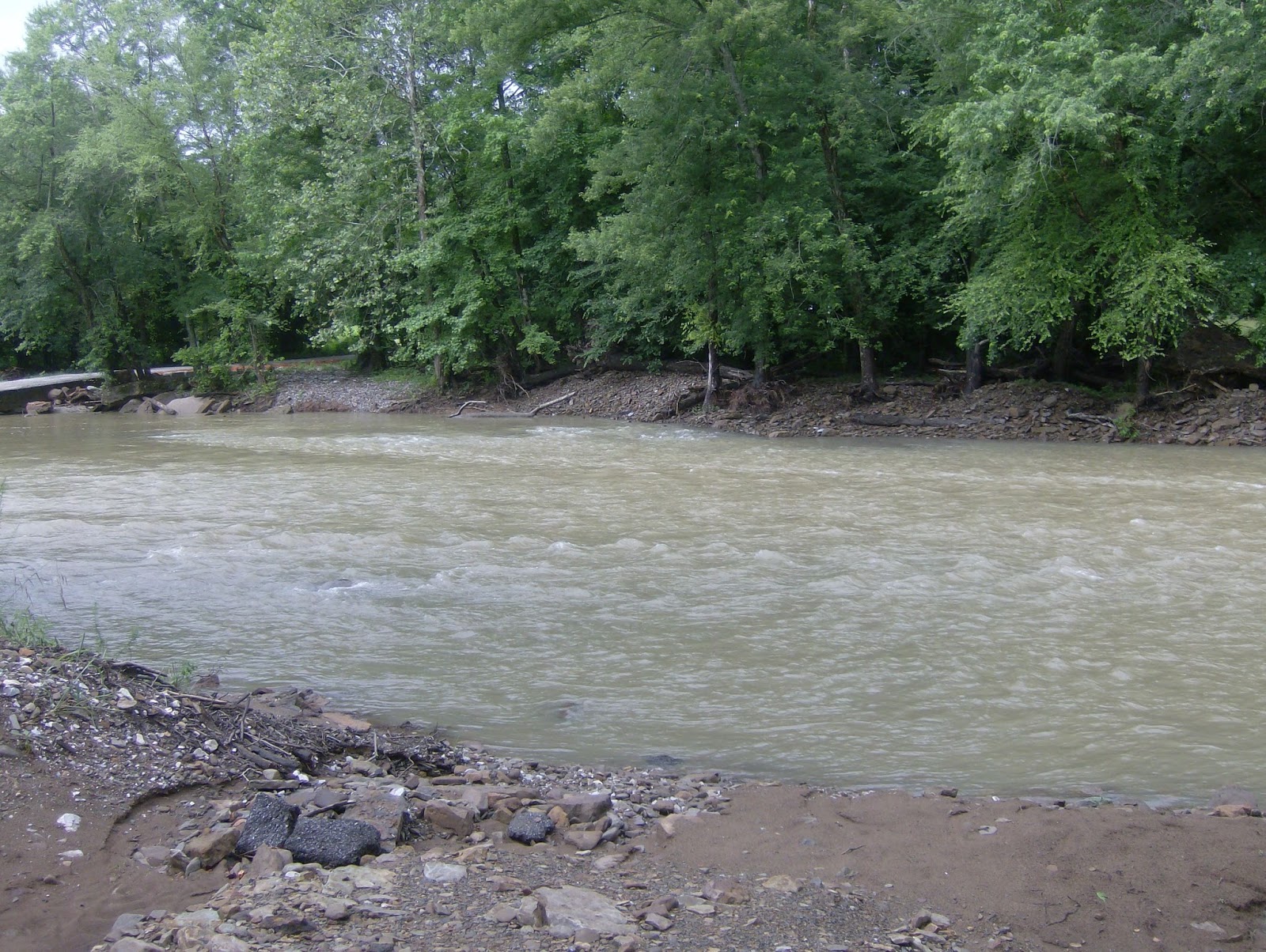
There was only one way to go. On the right side of the highway were a couple of buildings that looked abandoned. On the left was a road. Turning left off the highway, we soon came to a low bridge over a busy creek filled with all the recent rain. After just a moment of hesitation, Tim drove us over the bridge and up the road on the other side.
 |
| Scary bridge |
 |
| Looks like a creek from this side |
 |
| On this side it looks like a river |
My brother is never afraid to ask for directions. We saw a man in a county truck who affirmed we were on the right road for the Patrick Cemetery. We stopped again to ask two men working in a garage who directed us to the edge of a fence just visible down the road. This was the Patrick Cemetery, and soon we saw a stone etched with the name of the cemetery and an arrow directing us to the road on the left. After driving a road beside the fence, we were soon turning into the entrance.
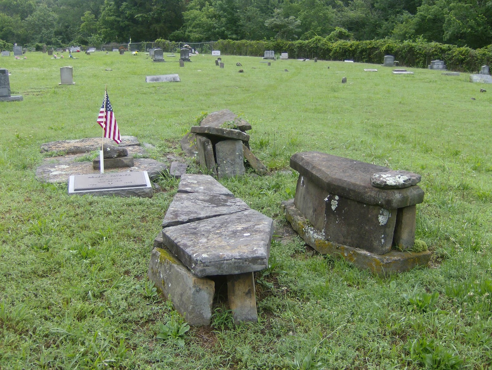
It's a pretty big cemetery. There were lots of Patricks, but we could see that there were a few other surnames that also had a large representation in the cemetery. I was looking for the older part of the cemetery. I had seen a picture of Robert Patrick's brass grave marker, and I knew there were larger stone markers around him. I was really not prepared for two large sarcophagi(?) next to Robert Patrick's grave. (I'm not sure that's what you call monuments of this sort in America, but that's what they looked like.) If you are a descendant also looking for these graves, they are just about in the center of the cemetery.
 |
| Robert Patrick grave and sarcophagi |
Robert's grave shows his birth and death years (1764-1859) and proclaims him as a veteran of the War of 1812. Both sarcophagi bear the faint trace of the name "Nancy." (One almost looks like it says "Nancy Tackett.") There may have been other information there at one time, but I couldn't see it.
(Note 6/26/15: Nancy Tackett appears to be the daughter of Mary Ann Patrick and her husband, William Mason Tackett. William and Mary Ann had 10 children. A photo on Ancestry.com, taken about 1885, shows 8 of the children. It was noted that one of the sons had died in war and Nancy had also died.)
 |
Robert Patrick
KY Militia
War of 1812
1764-1859 |
 |
| Nancy Tackett? |
 |
| Nancy Prater Patrick? |
So there lie my 4th great-grandfather and my maybe 4th great-grandmother in a quiet cemetery on the edge of a forest in Arkansas. I'm pretty sure my grandmother didn't know they were there. Robert Patrick was dead long before his granddaughter, Nancy Emily Reed Day, came to Oklahoma. Grandma Day was born in 1853, so she was only 6 and living in Kentucky when he died. She had never known him. It took well over 150 years (and the Internet, Ancestry.com, Findagrave, and Mapquest) for our branch of the family to find him again. I just wish he or Nancy could answer a couple of questions for me. Who was Sarah Patrick's mother? Why did you leave her in Kentucky when you moved to Arkansas? (See post "
DNA Circles: Robert Patrick and Elizabeth McMullen.")
We left out the back entrance of the cemetery, which probably was the original front entrance.
 |
| Patrick Cemetery original entrance? |
Here's the funny part of the story. The next part of our trip consisted of finding I-40 and following it into Oklahoma so we could visit our mother's grave in Dustin, OK. While I-40 crosses into Oklahoma at Ft. Smith, far south of our present location, it was easier to go north and catch it in Fayetteville. So we headed north again on Highway 16. Just outside of Elkins there was a huge traffic jam due to road work, so we stopped for breakfast at the McDonald's in Elkins and waited for the traffic to clear. Back on the now-clear Highway 16, we came to the outskirts of Fayetteville and a sign that said to turn left for 16 West. According to our map, this would take us to I-49 South and eventually to I-40.
Let's just say it was a scenic road. We drove and drove and drove through green, few houses in sight. Siri wouldn't help us. She thought we were in Iceland. We saw few road signs, which was very frustrating to my brother, but eventually we saw a sign down the road. It said Durham. Then we saw the sign for Crosses, then the one that said we were passing into Madison County. Again. Somehow we had gone north, turned west, and ended up south of Elkins. Again. When my brother finished fuming, we both began to laugh. Was it a vortex? Our own personal
Groundhog Day? A bad map, bad navigator (me)? We'll never know.


No comments:
Post a Comment